No products in the cart.
Winter storm warning expanded overnight to include more of Mass.
Winter storm warning issued for most of Massachusetts ahead of storm

Updated: 6:28 AM EST Jan 6, 2024
RIGHT? I KNOW, LET’S JUST SEE WHAT IT HAS. YEAH. WELL, YOU KNOW, IT’S THE FIRST ONE OF THE YEAR, SO EVERYONE’S ON EDGE, RIGHT? BUT I’M HERE TO SAY THAT WE’RE NOT TALKING ABOUT THE BIGGEST SNOW WE’VE EVER SEEN. RIGHT. THIS IS A GOOD STEADY SNOW THAT WILL BRING SOME SIGNIFICANT SNOWFALL TO AREAS. BUT I DO THINK IT’S SOMETHING. WE COULD HANDLE, ESPECIALLY CONSIDERING THE FACT THAT IT’S MOVING IN ON A SUNDAY. SO WE HAVE A COUPLE THINGS WORKING IN OUR FAVOR HERE. LET’S ALSO TALK ABOUT THE PEAK OF THE STORM. SO THIS IS WHEN THE SNOWFALL RATES WILL BE HEAVIEST 1 TO 2IN PER HOUR. THAT’S WHEN TRAVEL IS GOING TO BE MOST DIFFICULT. AND THAT IS EXPECTED OVERNIGHT. THAT’S SOMETHING THAT’S WORKING IN OUR FAVOR BECAUSE OF COURSE MANY OF US ARE SLEEPING NOT ON THE ROADS TRYING TO GET PLACE TO PLACE. AND SO REALLY IN THE OVERNIGHT, RIGHT, 11 THROUGH ABOUT THREE, 4:00 IN THE MORNING IS WHEN WE’RE SEEING THE WORST OF THIS STORM MOVING THROUGH. SO THAT WILL WORK IN OUR FAVOR IN REGARDS TO TRAVEL. HOWEVER, THAT DOES MEAN THAT WILL LIKELY SEE THAT SNOW QUICKLY PILE UP OVERNIGHT. OF COURSE, WE’RE WORKING WITH NIGHTTIME HOURS, MUCH COLDER AIR THAT MEANS THAT WE ARE LOOKING AT SOME SIGNIFICANT SNOWFALL TOTALS FOR AREAS OF OUR REGION. SO BY NO SURPRISE, WE HAVE WINTER STORM WARNINGS FOR MOST OF THE AREA, EVEN EXTENDING INTO BOSTON. AND REALLY MUCH OF 95 AND PORTIONS OF 24 AS YOU MOVE SOUTHEASTWARD. IT’S A WINTER WEATHER ADVISORY WHERE SLIGHTLY LESS IS EXPECTED, WITH MORE OF THAT MIXING EXPECTED AND CAPE ON THE ISLANDS YOU ARE OUTSIDE OF THESE ADVISORIES, YOU’RE GOING TO SEE MORE IN THE WAY. OF RAIN MIXING IN SO MUCH LESS IN THE WAY OF SNOWFALL. THIS IS THE STORM, AND IT’S PULLING ALL THAT MOISTURE FROM THE GULF, EXTENDING WITH RAINFALL FROM FLORIDA, SNOWFALL UP TOWARDS CHICAGO. SO THIS IS A BIG STORM THAT’S MOVING IN. WE’RE IN THE UPPER 20S TO LOW 30S RIGHT NOW, AND UNTIL THAT STORM ARRIVES, IT’S RELATIVELY QUIET OUT THERE. WE HAVE SOME BREAKS IN THE CLOUD DECK. SO WITH SUNRISE JUST ABOUT A QUARTER PAST SEVEN, YOU’LL SEE A LITTLE BIT OF COLOR, BUT THAT SUN WILL GIVE WAY TO A LOT OF CLOUDS BY BY MID TO LATE MORNING HERE. SO WE’RE TALKING ABOUT MORE CLOUDS AND SUN AS WE TOP OUT IN THE MID TO UPPER 30S THIS AFTERNOON. NOW WITH SOME OF THESE THICKER CLOUDS AND AN EAST WIND DEVELOPING, I WOULDN’T BE SURPRISED. WE START TO SEE SOME OCEAN EFFECT FLURRIES IN EASTERN MASSACHUSETTS. DON’T BE SURPRISED BY THIS. THIS IS NOT THE STORM. THESE ARE OCEAN EFFECT SNOW FLURRIES THAT ARE MOVING IN, AND IT’S SOMETHING YOU’LL LIKELY SEE BETWEEN NOON TO ABOUT 5:00 THIS EVENING. BY SEVEN, WE’RE SEEING THE ACTUAL STORM MOVING IN FROM THE WEST, AND THIS IS GOING TO BE THE FIRST LINE APPROACHING FROM THE WEST AS WE MOVE TOWARD ABOUT NINE. THAT SHOULD MOVE TOWARD THE COASTLINE, INTO BOSTON. AND REALLY, AFTER NINE IS WHEN CONDITIONS TAKE A TURN HERE. BY MIDNIGHT, WE’RE IN THE PEAK OF THE STORM, HEAVY SNOWFALL, BUT ALSO STRONG WIND FOR SOUTHEASTERN MASSACHUSETTS, WHERE THERE’S SOME RAIN MIXING IN AS WE MOVE TOWARD 4 A.M. STILL IN THE PEAK OF THE STORM. HEAVY SNOWFALL IN PLACE BEYOND FOUR. WE’RE LOOKING AT A WIDESPREAD STORM HERE, MAINLY SNOWFALL, BUT THIS IS GOING TO BE LIGHT TO MODERATE SNOW FOLK. SO FALLING DOWN AT A CLIP THAT’S A LITTLE EASIER TO MANAGE THAT WILL BE THE NATURE OF THE STORM INTO THE AFTERNOON EARLY AFTERNOON. STILL SOME SNOWFALL AROUND PRETTY STEADY, BUT BY MID AFTERNOON THREE 4:00 YOU CAN SEE THINGS ARE TAPERING OFF HERE, SO WE WILL DRY OUT BY TOMORROW NIGHT. IT’S A WETTER SNOWFALL AS YOU MOVE TOWARD THE COASTLINE AND INTO SOUTHEASTERN MASSACHUSETTS, WHERE WE’RE TALKING ABOUT HEAVIER TOTALS. IT’S A FLUFFIER SNOWFALL, SO THIS 9 TO 12 INCH MARK IS A FLUFFY TYPE. OF SNOWFALL. LET’S TAKE YOU FOCUSED IN HERE, LOWELL LAWRENCE. YOU ARE INCLUDED IN THE 9 TO 12 INCH MARK EXTENDING UP TOWARD MANCHESTER FOR MUCH OF ROUTE TWO. TRAVEL AS YOU GO WEST OF 495 AND THROUGH MUCH OF WORCESTER COUNTY. METROWEST 6 TO 9IN 3 TO 6IN. AS YOU MOVE INSIDE OF 1 TO 8 IMMEDIATE COASTLINE OF BOSTON, YOU’RE 1 TO 3. THAT INCLUDES WINTHROP AND AS YOU MOVE DOWN TOWARD QUINCY, RIGHT ALONG THE IMMEDIATE COASTLINE OF PLYMOUTH COUNTY, 1 TO 3IN, EXTENDING DOWN TOWARD CAPE COD, 3 TO 6IN AS YOU MOVE INLAND AND THEN A LITTLE MORE AS YOU MOVE JUST WEST OF 24, 30 TO 40 MILE PER HOUR WIND GUSTS EXPECTED INTO BOSTON, A LITTLE STRONGER DOWN TOWARD CAPE COD, THE ISLAND. SO IT IS GOING TO BE A GUSTY DAY FOR US AS WE TRAVEL THROUGH THE NEXT 24 HOURS. ALSO, WATCH OUT, THERE’S GOING TO BE MUCH COLDER AIR WORKING IN TOMORROW AFTERNOON. THAT MEANS, IN ADDITION TO SNOWY TRAVEL, WE’RE ALSO
Advertisement
Winter storm warning issued for most of Massachusetts ahead of storm
Updated: 6:28 AM EST Jan 6, 2024
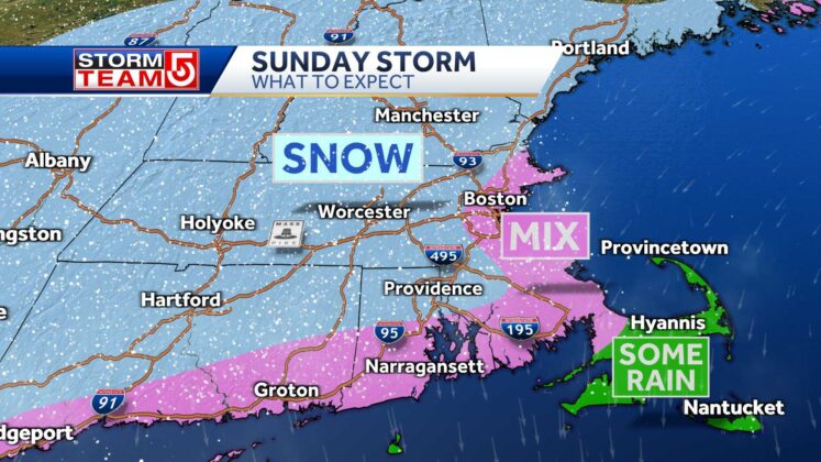
Much of Massachusetts is under a winter storm warning because of a significant snowstorm that’s expected to strike Massachusetts, New Hampshire and other New England states this weekend, StormTeam 5 meteorologists say.The greatest impacts from the storm will reach the greater Boston area Saturday evening after sunset and continue through part of the day on Sunday. Peak snowfall rates are expected to occur overnight.Forecast tools: Weather Alerts | Futurecast | ClosingsThe National Weather Service issued a winter storm warning for much of Massachusetts, including Boston, the North Shore, central and western parts of the state. NWS meteorologists cited the likelihood of heavy snow and gusty winds, which could make travel difficult and lead to power outages.The storm grabbed energy and moisture from the Gulf of Mexico before beginning to move up the East Coast. The heaviest snow and largest amounts of snow from this storm will fall over inland areas because gusty winds will be blowing in over the warmer ocean waters. Snowfall intensity is expected to peak overnight. “There will be that mixing near the coast and the wind, too, will be strongest on the Cape, where we could see gusts up close to 50 miles per hour,” StormTeam 5 Chief Meteorologist Cindy Fitzgibbon said.Snow will gradually increase in intensity late Saturday night, with the heaviest snow falling overnight into Sunday morning. Forecast tools: Weather Maps | Watch on VeryLocalBy early afternoon, more cold air will move south, changing mixed precipitation in southeastern Massachusetts to snow. “Right along the coast as you go from Boston down through the South Shore, east of Route 24, we’re talking about mixing that could hold the totals down to as little as just 3 inches of snow or, if there’s less mixing, we could get closer to 6,” Fitzgibbon said. From Plymouth out to the Cape, temperatures will stay above freezing until a sharp drop in the late afternoon and evening.”Be careful about that flash freeze in the southeastern part of the state,” StormTeam 5 Meteorologist Mike Wankum said.So far this winter, a flow of air from the Pacific Ocean has kept most of the country very mild, including New England. This has caused most of the storms in November and December to produce rain versus snow across the Northeast.
BOSTON —


Much of Massachusetts is under a winter storm warning because of a significant snowstorm that’s expected to strike Massachusetts, New Hampshire and other New England states this weekend, StormTeam 5 meteorologists say.
The greatest impacts from the storm will reach the greater Boston area Saturday evening after sunset and continue through part of the day on Sunday. Peak snowfall rates are expected to occur overnight.
Advertisement
Forecast tools: Weather Alerts | Futurecast | Closings
The National Weather Service issued a winter storm warning for much of Massachusetts, including Boston, the North Shore, central and western parts of the state. NWS meteorologists cited the likelihood of heavy snow and gusty winds, which could make travel difficult and lead to power outages.
The storm grabbed energy and moisture from the Gulf of Mexico before beginning to move up the East Coast.
The heaviest snow and largest amounts of snow from this storm will fall over inland areas because gusty winds will be blowing in over the warmer ocean waters. Snowfall intensity is expected to peak overnight.
“There will be that mixing near the coast and the wind, too, will be strongest on the Cape, where we could see gusts up close to 50 miles per hour,” StormTeam 5 Chief Meteorologist Cindy Fitzgibbon said.
Snow will gradually increase in intensity late Saturday night, with the heaviest snow falling overnight into Sunday morning.
Forecast tools: Weather Maps | Watch on VeryLocal
By early afternoon, more cold air will move south, changing mixed precipitation in southeastern Massachusetts to snow.
“Right along the coast as you go from Boston down through the South Shore, east of Route 24, we’re talking about mixing that could hold the totals down to as little as just 3 inches of snow or, if there’s less mixing, we could get closer to 6,” Fitzgibbon said.
From Plymouth out to the Cape, temperatures will stay above freezing until a sharp drop in the late afternoon and evening.
“Be careful about that flash freeze in the southeastern part of the state,” StormTeam 5 Meteorologist Mike Wankum said.
So far this winter, a flow of air from the Pacific Ocean has kept most of the country very mild, including New England. This has caused most of the storms in November and December to produce rain versus snow across the Northeast.