No products in the cart.
Wind-driven, soaking rain for part of weekend in Mass.
Wind-driven, soaking rain for part of weekend in Massachusetts

Updated: 8:41 PM EST Dec 8, 2023
THAT’S HOW WE WARM UP SO SIGNIFICANTLY TONIGHT. NOT AS COLD. WE HAVE A FEW CLOUDS DRIFTING THROUGH. AS I MENTIONED A MOMENT AGO, THOSE ARE RUNNING OUT AHEAD OF THIS SPIN THAT YOU SEE DEVELOPING OVER THE DAKOTAS. IT WILL SCOOP UP MOISTURE FROM THE GULF AND ROCKET IT TOWARDS US FOR THE END OF THE WEEKEND. THAT’S HOW WE END UP WITH A PERIOD OF POWERFUL WINDS AND DOWNPOURS. BUT TONIGHT, 28 TO 38, SOME OF THE CHILLIER SPOTS ACTUALLY ON THE CAPE RIGHT NOW. BUT GENERALLY SPEAKING, NOT AS COLD WITH A FEW EXTRA CLOUDS IN THAT LIGHT SOUTH WIND. THERE ARE THE 54 TOMORROW ABOVE AVERAGE FOR A CHANGE. MERRIMACK VALLEY, SOUTHERN NEW HAMPSHIRE, ROUTE TWO, YOU’LL STILL BE STUCK IN THE UPPER 40S, BUT OVERWHELMINGLY A NICE DAY. THE PICK OF THE WEEKEND TOMORROW FOR ANY HOLIDAY PLANS THAT YOU HAVE OUTSIDE. WE ARE STARTING DRY ON FUTURE CAST FOR SUNDAY AT 8:00. THERE’S YOUR TIMESTAMP ALREADY MILD WITH THE CONTINUED SOUTHERLY WIND. BUT WATCH HOW THE WET WEATHER SETTLES IN AS WE GO DEEPER THROUGH THE MORNING AND ESPECIALLY AROUND LUNCHTIME. HERE’S NOON NOW NORTH AND WEST OF BOSTON IN PARTICULAR. THIS IS WHERE THE RAIN COMES IN FIRST AND WHERE IT WILL BE COMING THROUGH IN REPEATED WAVES. MEANWHILE, SOUTH AND EAST OF BOSTON, BY CONTRAST. SURE, A LIGHT SHOWER HERE OR THERE, BUT MOST OF THE DAY WILL BE DRY AS YOU GO DOWN ROUTE 324 AND CERTAINLY ALONG ROUTE SIX. YOU SEE MORE OF THIS NOW AT 2:00. WETTEST WEATHER NORTH AND WEST, BETTER CHANCE OF STAYING DRY WITH SOME LIGHTER SHOWERS SOUTH AND EAST. THIS IS ALSO WHERE WE EVENTUALLY HAVE THE STRONGEST WINDS OVERNIGHT. HERE’S 6:00. TEMPERATURES NEAR 60 DEGREES. AND WE’RE JUST WAITING FOR THE PULSE OF HEAVIEST DOWNPOURS. THIS IS WHAT HAPPENS OVERNIGHT, JUST LIKE A COUPLE OF WEEKS AGO, A SLUG OF HEAVY RAIN COMES THROUGH OVERNIGHT, DRENCHING DOWNPOURS AS MILD AIR FUNNELED UP ON A SOUTHERLY WIND. AND WE’LL HAVE GUSTS. BETWEEN 50 AND 65MPH. AT THIS TIME, SOMEONE WAS ASKING, IS THIS A NOR’EASTER? WELL, NO, BECAUSE THE WINDS OUT OF THE SOUTH, THE STORM ITSELF IS WHAT WE CALL AN INSIDE RUNNER. IT’S GOING INLAND THROUGH NEW ENGLAND. SO WE’RE ON THE WARM, WET SIDE OF THIS. THE EARLY COMMUTE ON MONDAY STILL SOAKED WITH DOWNPOURS, VERY SLOW EARLY ON MONDAY WITH CONTINUED STRONG WINDS. AND THEN WATCH WHAT HAPPENS. VERY CAREFULLY. IF YOU PAY ATTENTION, YOU’LL SEE THE WIND SWITCHING DIRECTION TO THE WEST. TEMPERATURES WILL PLUMMET OVER THE COURSE OF THE DAY. IN FACT, THERE MIGHT EVEN BE A ROGUE SNOWFLAKE THAT MAKES IT TO THE WORCESTER HILLS AS A COLDER AIR RUSHES IN LATER IN THE DAY ON MONDAY BETWEEN, LET’S SAY, MID-MORNING AND MIDDAY AND SOME SUNSHINE BREAKS OUT DURING THE AFTERNOON, LOCALLY STILL KEEPS SNOWING AND SKI COUNTRY. SO THERE WILL BE SNOW UP NORTH ON THE BACK SIDE. DON’T FOCUS ON EXACTLY WHERE THIS AXIS OF HEAVY RAIN IS BEING PAINTED, BUT THE TREND IS GOOD, MEANING THAT THAT I EXPECT THE HEAVIEST RAIN NORTH AND WEST OF BOSTON, 1 TO 3IN THERE, A LITTLE BIT LESS RAIN, BUT MORE WIND SOUTH AND EAST. AND OVER THE NEXT COUPLE OF DAYS, WE’LL BE FINE TUNING EXACTLY WHERE THE HEAVIEST RAIN IS. BUT CLEAR YOUR GUTTERS, CLEAR THE STORM DRAINS, CHECK YOUR SUMP PUMP, THAT TYPE SITUATION WITH THE STRONGEST WINDS, LIKE I SAID, PEAKING 50 TO 65MPH. HOLD ON TO THOSE HOLIDAY DECORATIONS OUT IN THE FRONT YARD. YOU’LL BE CHASING THOSE DOWN THE STREET IF THEY’RE NOT TIED DOWN SUNDAY NIGHT INTO MONDAY. NICE MIDWEEK, THOUGH. IT’S QUIET AFTER THIS SYSTEM SEASONABLE, TOO, WITH TEMPERATURES IN THE MID 40S. SO THE BIG FOCUS SUNDAY NIGHT INTO MONDAY WITH THAT
Advertisement
Wind-driven, soaking rain for part of weekend in Massachusetts
Updated: 8:41 PM EST Dec 8, 2023
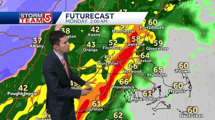
A wind-driven, soaking rain will move into Massachusetts and parts of New England on Sunday and last through Monday. A strong storm will lift into the Great Lakes this weekend. To the east, or out ahead of the storm, milder air will be drawn northward into New England, sending temperatures up to 50 degrees or higher by Saturday.As the storm gets closer, rain will begin to move into New England later in the day on Sunday. The wind will also increase and become quite strong Sunday night through Monday morning. “There will be a little bit of snow on the backside, but this is mainly a rain event and it certainly will be for us as it comes in here as we go from Sunday into Monday,” StormTeam 5 chief meteorologist Cindy Fitzgibbon said.Fitzgibbon said about 1 to 2 inches of rain is expected.Rain will move into parts of Massachusetts beginning late on Sunday morning, especially across northern and western parts of the state.The heaviest downpours are projected to move across parts of eastern Massachusetts during the overnight hours of Sunday into Monday.”This is going to have a high impact on the Monday morning commute. You can expect a period of heavy rain and also strong winds which make us 50 to even over 60 miles per hour in southeastern Massachusetts and along the coastline,” Fitzgibbon said.Fitzgibbon said there could be some poor drainage flooding during the morning commute on Monday. “In addition to that, could have some power outages. And along our south facing coastline, we will watch that high tide early Monday morning for the potential of some minor coastal flooding. So it is going to be a stormy end to the weekend and a stormy start early next week,” Fitzgibbon said.
NEEDHAM, Mass. —
A wind-driven, soaking rain will move into Massachusetts and parts of New England on Sunday and last through Monday.
A strong storm will lift into the Great Lakes this weekend. To the east, or out ahead of the storm, milder air will be drawn northward into New England, sending temperatures up to 50 degrees or higher by Saturday.
Advertisement
As the storm gets closer, rain will begin to move into New England later in the day on Sunday. The wind will also increase and become quite strong Sunday night through Monday morning.
“There will be a little bit of snow on the backside, but this is mainly a rain event and it certainly will be for us as it comes in here as we go from Sunday into Monday,” StormTeam 5 chief meteorologist Cindy Fitzgibbon said.
Fitzgibbon said about 1 to 2 inches of rain is expected.
Rain will move into parts of Massachusetts beginning late on Sunday morning, especially across northern and western parts of the state.
The heaviest downpours are projected to move across parts of eastern Massachusetts during the overnight hours of Sunday into Monday.
“This is going to have a high impact on the Monday morning commute. You can expect a period of heavy rain and also strong winds which make us 50 to even over 60 miles per hour in southeastern Massachusetts and along the coastline,” Fitzgibbon said.
Fitzgibbon said there could be some poor drainage flooding during the morning commute on Monday.
“In addition to that, could have some power outages. And along our south facing coastline, we will watch that high tide early Monday morning for the potential of some minor coastal flooding. So it is going to be a stormy end to the weekend and a stormy start early next week,” Fitzgibbon said.