No products in the cart.
Tornado warning for parts of Rhode Island as cold front moves across New England

A tornado warning was posted for parts of northern Connecticut and western Rhode Island amid severe thunderstorms moving through the area. The severe thunderstorm capable of producing a tornado was located near Foster, or 10 miles northeast of Plainfield, moving east at 25 mph, according to the National Weather Service. The warning, in effect until 4:45 p.m.Flying debris will be dangerous to those caught without shelter. Mobile homes will be damaged or destroyed. Damage to roofs, windows, and vehicles will occur. Tree damage is likely.Meteorologists say the communities of Johnston, Smithfield, Scituate, Glocester, Foster Cranston, Burrillville and North Smithfield.More rain was falling across Massachusetts on Wednesday after a stretch of heavy rain and historic rainfall resulted in destructive flooding earlier in the week.StormTeam 5 is calling Wednesday an Impact Weather Day.A Flash Flood Watch is in effect through Thursday morning for most of eastern Massachusetts, Rhode Island, southern New Hampshire and Connecticut. “We’re tracking the likelihood for more downpours and there is that chance for pockets of 2 to 4 inches. So, we remain on alert for that potential for flooding through the night,” StormTeam 5 Meteorologist Kelly Ann Cicalese said. The threat continues through the afternoon and night.Weather Alerts | Interactive RadarBy mid-afternoon to mid-evening, showers and thunderstorms will move into the greater Boston area and eastern Massachusetts. Localized flooding may again develop along with impacts for the Wednesday afternoon commute.”We’ll hold on to the potential for storms into the evening commute with downpour potential, but also the threat of damaging wind,” Cicalese said. “These storms could turn severe in spots, and there’s even a low risk for a spin up or two.”The risk of severe weather will remain until about 9 or 10 p.m. Wednesday.Much drier and more seasonable weather will arrive for Thursday into at least Friday, although Hurricane Lee still could make a closer pass of the Massachusetts coastline this weekend.
BOSTON —
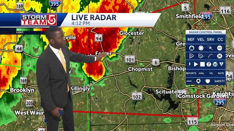
A tornado warning was posted for parts of northern Connecticut and western Rhode Island amid severe thunderstorms moving through the area.
The severe thunderstorm capable of producing a tornado was located near Foster, or 10 miles northeast of Plainfield, moving east at 25 mph, according to the National Weather Service.
Advertisement
The warning, in effect until 4:45 p.m.
Flying debris will be dangerous to those caught without shelter. Mobile homes will be damaged or destroyed. Damage to roofs, windows, and vehicles will occur. Tree damage is likely.
Meteorologists say the communities of Johnston, Smithfield, Scituate, Glocester, Foster Cranston, Burrillville and North Smithfield.
More rain was falling across Massachusetts on Wednesday after a stretch of heavy rain and historic rainfall resulted in destructive flooding earlier in the week.
StormTeam 5 is calling Wednesday an Impact Weather Day.
A Flash Flood Watch is in effect through Thursday morning for most of eastern Massachusetts, Rhode Island, southern New Hampshire and Connecticut.
“We’re tracking the likelihood for more downpours and there is that chance for pockets of 2 to 4 inches. So, we remain on alert for that potential for flooding through the night,” StormTeam 5 Meteorologist Kelly Ann Cicalese said.
The threat continues through the afternoon and night.
Weather Alerts | Interactive Radar
By mid-afternoon to mid-evening, showers and thunderstorms will move into the greater Boston area and eastern Massachusetts. Localized flooding may again develop along with impacts for the Wednesday afternoon commute.
“We’ll hold on to the potential for storms into the evening commute with downpour potential, but also the threat of damaging wind,” Cicalese said. “These storms could turn severe in spots, and there’s even a low risk for a spin up or two.”
The risk of severe weather will remain until about 9 or 10 p.m. Wednesday.
Much drier and more seasonable weather will arrive for Thursday into at least Friday, although Hurricane Lee still could make a closer pass of the Massachusetts coastline this weekend.