No products in the cart.
Snow making for slick roads in parts of Mass.
Winter storm, snow making for slick roads in parts of Massachusetts

Updated: 8:46 AM EST Jan 16, 2024
AND A GOOD TUESDAY TO YOU. A SNOWY START TO THE DAY WITH A LITTLE BURST OF SNOW OVERNIGHT INTO EARLY THIS MORNING, PRODUCING ONE TO UP TO 2.5IN AROUND MANSFIELD. WE HAD THAT BURST OF SNOW ON THE CAPE, THE SOUTH COAST, ABOUT AN INCH AND A HALF IN THE CAMBRIDGE AREA AS WELL. AND NOTICE THE SNOW CONTINUES TO FLY, BUT WE ARE STARTING TO SEE THAT CHANGE OVER TO RAIN WITH A LITTLE BIT OF MIXING HAPPENING FOR THE ISLANDS, THE SOUTH COAST, AND THIS IS GOING TO CONTINUE TO CREEP NORTHWARD ON THROUGH CAPE COD THIS MORNING. STORM ITSELF IS TO OUR SOUTH, AND AS IT LIFTS NORTHWARD IT’S GOING TO DRAW IN NOT ONLY SOME MILDER AIR OFF THE OCEAN, BUT ALSO SOME MILDER AIR ALOFT. AND THAT MEANS WHERE IT IS SNOWING, WE’RE GOING TO START TO MIX IN SOME SLEET FREEZING RAIN AND RAIN IN SOME AREAS, BUT IT IS SNOWING FOR THE MORNING COMMUTE. WATCH FOR SLICK ROADS, SLOW TRAVEL. IT’S REALLY GOING TO BE MIDDAY INTO THE AFTERNOON THAT WE SEE MORE OF THAT ICY MIX AND RAIN DEVELOPING, AND YOU CAN SEE WHERE I AM MOST CONCERNED FOR A LITTLE GLAZE OF ICE HERE. PARTS OF SOUTHERN WORCESTER COUNTY UP THROUGH THE BLACKSTONE VALLEY, METRO WEST AND ON UP INTO THE MERRIMACK VALLEY AS WELL. THIS IS WHERE ANY ICE ACCRETION WILL BE UNDER A 10TH OF AN INCH, BUT THAT IS ENOUGH TO CREATE SLICK SPOTS ON THE ROADS AND AN ICY GLAZE TO AND BASICALLY ON TOP OF THE SNOW THAT WE’RE SEEING. THIS MORNING, NORTH AND WEST OF HERE. ONCE YOU GO BEYOND 495, YOU’RE MAINLY SNOW. AND THAT’S WHERE WE COULD ACCUMULATE MORE THAN THREE INCHES OF SNOW. IT’S GOING TO BE A LITTLE FLUFFY, FLUFFIER SNOW TOO, AS YOU GET CLOSER TO THE COAST. 1 TO 3IN OF SNOW WITHIN THAT CHANGEOVER ON TOP. AND A LOT OF WHAT YOU DO GET ARE GOING TO GET WASHED AWAY THIS AFTERNOON. PLYMOUTH SOUTH IS THE TEMPERATURES BRIEFLY COME UP TO AROUND AND OVER 40 DEGREES. BUT NOTICE JUST NORTH AND WEST OF BOSTON, EVEN WHERE WE GET SOME OF THAT SLEET AND FREEZING RAIN, TEMPERATURES HOLD IN THE LOW TO MID 30S, SO THAT’S WHY IT MAY STAY SLICK RIGHT ON INTO THE AFTERNOON. SO TAKE A LOOK AT THE TIMING HERE. BY MIDDAY TODAY WE ARE RAINING IN SOUTH EASTON, MASSACHUSETTS. WE’LL HAVE SOME RAIN MIXING IN AROUND BOSTON, BUT THERE COULD BE SLEET AND FREEZING RAIN EXTENDING BACK NEAR AND SOUTH OF THE PIKE. AND THEN LOOK WHAT HAPPENS BY MID-AFTERNOON, THAT SLEET AND FREEZING RAIN AREA MAY START TO SHIFT CLOSER TO 4.95 INTO THE MERRIMACK VALLEY AND BACK THROUGH METRO WEST AS WELL. STILL SNOWING THOUGH. NORTH OF WORCESTER, THE ROUTE TWO CORRIDOR, SOUTHERN NEW HAMPSHIRE. AND THIS IS WHERE WE’RE GOING TO GET THE MOST AMOUNT OF SNOW. AND THEN BETWEEN THREE AND 6 P.M., LOOK HOW THIS STARTS TO ALL PULL AWAY. THIS MAY END AS A BURST OF SNOW. SIX 7:00 THIS EVENING. AND THEN IT’S ALL DONE WITH SKIES CLEARING OUT HERE THROUGH THE OVERNIGHT HOURS. BUT WATCH OUT FOR SLICK SPOTS REDEVELOPING TONIGHT. TEMPERATURES ARE GOING TO FALL INTO THE TEENS TO AROUND 20 DEGREES BY TOMORROW MORNING. AND IT IS A COLD BUT A BRIGHT DAY TOMORROW. TEMPERATURES STUCK IN THE 20S TO AROUND 30 DEGREES, AND THAT WIND WILL BE BLOWING OUT OF THE WEST TEN 15MPH, GUSTING A LITTLE HIGHER. SO THIS IS WHAT IT’S GOING TO FEEL LIKE. WIND CHILLS STUCK IN THE TEENS ALL DAY LONG. LESS WIND, BUT THE COLD CONTINUES TO POUR IN HERE AS WE GO INTO THURSDAY AS WELL. BUT DRY WEATHER FOR A COUPLE OF DAYS WEDNESDAY INTO THURSDAY. AND THEN WE’VE BEEN EYEING FRIDAY FOR THE POTENTIAL OF SOME SNOW. THERE IS GOING TO BE A STORM DEVELOPING OFFSHORE, AND IT IS NOW LOOKING A LITTLE FARTHER OUT, SO WE’LL SEE IF IT COMES CLOSE ENOUGH THAT WE GET IN ON ANY SNOW ON FRIDAY. BUT AS IT PULLS AWAY FRIDAY NIGHT AND SATURDAY, ANOTHER SURGE OF COLDER AIR IS GOING TO COME ON IN. SO SUNSHINE BUT COLD
Advertisement
Winter storm, snow making for slick roads in parts of Massachusetts
Updated: 8:46 AM EST Jan 16, 2024
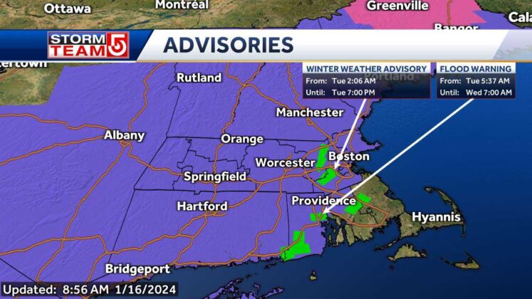
A coastal storm that is bringing accumulating snow and ice across parts of Massachusetts on Tuesday is expected to change to rain near the South Coast and Cape Cod.”The snow continues to fly, but we are starting to see that changeover to rain with a little mixing happening,” StormTeam 5 chief meteorologist Cindy Fitzgibbon said. Latest closings and delays Winter weather advisories have been posted for most of Massachusetts, except for the Southeastern part of the state and the Cape and Islands. Interactive Radar | Hour-by-hour forecastNational Weather Service meteorologists say a threat for freezing rain and icy mix exists across Rhode Island and into Northeast Massachusetts. Snow accumulations will be low along the Massachusetts coastline, generally between 1-3 inches around the city of Boston and inside of Route 128. Accumulations could reach up to 5 inches across interior sections of Massachusetts, especially in higher elevations. As low pressure lifts north, milder air will be drawn in, creating an icy mix.”Boston will see that change over right around noon time, but it will be still snowing to the north. This all will pull away by 7 p.m., and we will see clearing overnight,” Fitzgibbon said. “Temperatures will drop into the teens, so watch out for slick spots.Sun returns Wednesday, however high temperatures will linger in the 20s.
BOSTON —


A coastal storm that is bringing accumulating snow and ice across parts of Massachusetts on Tuesday is expected to change to rain near the South Coast and Cape Cod.
“The snow continues to fly, but we are starting to see that changeover to rain with a little mixing happening,” StormTeam 5 chief meteorologist Cindy Fitzgibbon said.
Advertisement
Winter weather advisories have been posted for most of Massachusetts, except for the Southeastern part of the state and the Cape and Islands.
Interactive Radar | Hour-by-hour forecast
National Weather Service meteorologists say a threat for freezing rain and icy mix exists across Rhode Island and into Northeast Massachusetts.
Snow accumulations will be low along the Massachusetts coastline, generally between 1-3 inches around the city of Boston and inside of Route 128.
Accumulations could reach up to 5 inches across interior sections of Massachusetts, especially in higher elevations.
As low pressure lifts north, milder air will be drawn in, creating an icy mix.
“Boston will see that change over right around noon time, but it will be still snowing to the north. This all will pull away by 7 p.m., and we will see clearing overnight,” Fitzgibbon said. “Temperatures will drop into the teens, so watch out for slick spots.
Sun returns Wednesday, however high temperatures will linger in the 20s.