No products in the cart.

Afternoon storms possible in parts of Mass.; Tropical storm Erin churns

The heat is in full swing in Massachusetts this week, with humidity climbing and tropical-like dew points by Thursday. StormTeam 5 tools: Alerts | Radar | Map Room There is another chance of showers and thunderstorms on Thursday as a cold front moves through. Temperatures will be slightly cooler than previous days, but still muggy with high dew points. “The storms today will be hit or miss,” StormTeam 5 chief meteorologist Cindy Fitzgibbon said. “It will be beneficial rain where you get it, and the best chance for rain is across eastern most Massachusetts.” Storms will develop during the afternoon hours, and some of the storms may bring lightning and downpours.”The storms are going to be around until about 7 p.m. So the evening commute, you may drive through a downpour,” Fitzgibbon said.Tropical Storm Erin, the fifth named storm of the Atlantic hurricane season, is expected to strengthen into the first hurricane of the season Thursday night and possibly a major hurricane by the weekend. Video: When could Erin bring rip currents to New England?As it moves west in the Atlantic, it is not expected to hit any land areas through the weekend, but it will strengthen in the warm waters. By next Thursday, the storm is expected to make its closest approach to Massachusetts, but it will be several hundred miles offshore. The East Coast will still have the risk of dangerous rip currents from Erin next week, with perhaps a closer pass to Bermuda.StormTeam 5 has labeled Thursday as an Impact Weather Day.Boston averages 14 days per year that reach 90 degrees. So far in 2025, the city has recorded 18.
BOSTON —
The heat is in full swing in Massachusetts this week, with humidity climbing and tropical-like dew points by Thursday.
StormTeam 5 tools: Alerts | Radar | Map Room
Advertisement
There is another chance of showers and thunderstorms on Thursday as a cold front moves through. Temperatures will be slightly cooler than previous days, but still muggy with high dew points.
“The storms today will be hit or miss,” StormTeam 5 chief meteorologist Cindy Fitzgibbon said. “It will be beneficial rain where you get it, and the best chance for rain is across eastern most Massachusetts.”
Storms will develop during the afternoon hours, and some of the storms may bring lightning and downpours.
“The storms are going to be around until about 7 p.m. So the evening commute, you may drive through a downpour,” Fitzgibbon said.
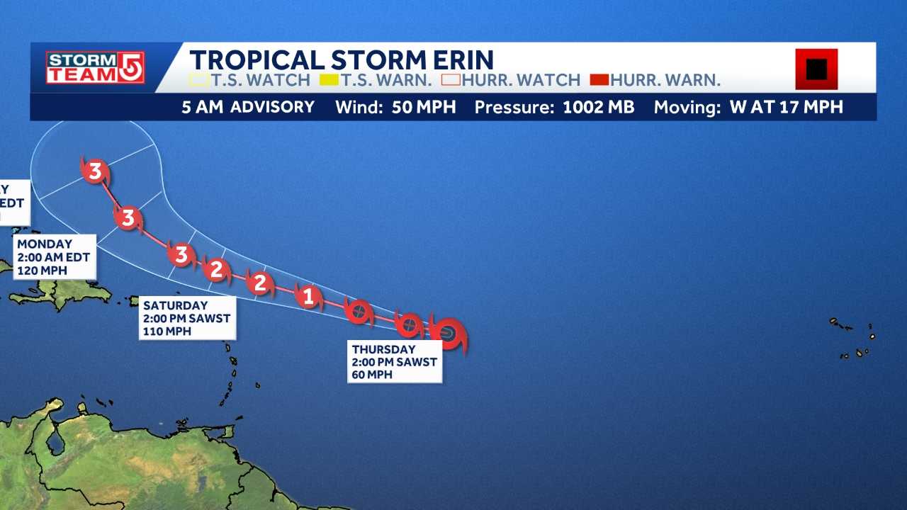
Tropical Storm Erin, the fifth named storm of the Atlantic hurricane season, is expected to strengthen into the first hurricane of the season Thursday night and possibly a major hurricane by the weekend.
Video: When could Erin bring rip currents to New England?
As it moves west in the Atlantic, it is not expected to hit any land areas through the weekend, but it will strengthen in the warm waters.
By next Thursday, the storm is expected to make its closest approach to Massachusetts, but it will be several hundred miles offshore. The East Coast will still have the risk of dangerous rip currents from Erin next week, with perhaps a closer pass to Bermuda.
StormTeam 5 has labeled Thursday as an Impact Weather Day.
Boston averages 14 days per year that reach 90 degrees. So far in 2025, the city has recorded 18.


